Showing posts with label towerJunction. Show all posts

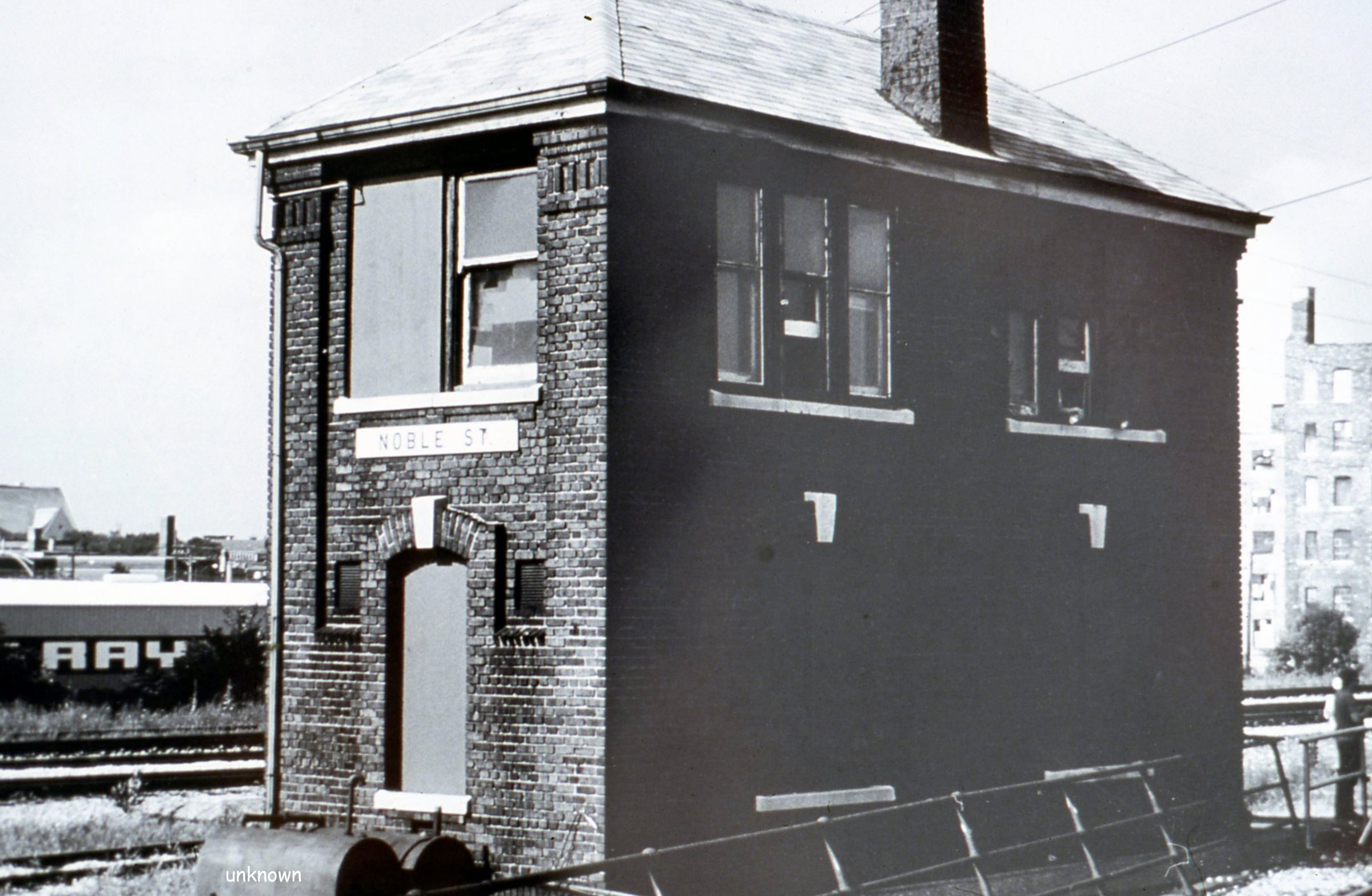
C&NW Noble Street Tower: C&NW passenger main vs. C&NW local freight

(Satellite)  Closed in 1980
NorthAmericanInterlockings:  photo
Chicago and Northern Indiana Railroad Interlocking Towers (click the marker for the correct information)

Steven J. Brown posted
Metra F40PH 177 at the site of the former Noble Street Tower in Chicago - November 5, 2001.
I shared
UP/C&NW on the left and Metra/(Milwaukee + Pennsy's Panhandle) on the right. The spur is gone, but they still store track supplies where the tower stood: https://www.google.com/…/@41.8888377,-87.6620…/data=!3m1!1e3
David Daruszka Noble Street was a C&NW tower. It controlled the junction between the Galena Division tracks that went to the Madison Street CPT and the old line that ran to Wells Street Station. Those tracks were used for local freights.
Jon Roma I think the tower lasted till the early Eighties.
1938 Aerial Photo from ILHAP
Dennis DeBruler In 1938 there was an incredible amount of track in the area.
1938 Aerial Photo from ILHAP
Dennis DeBruler An incredible amount of track! Note the viaduct that used to carry Milwaukee Avenue southeast to Canal Street.
The triangular building that we can see next to the viaduct still exists.

Fortunately, David's comment steered me away from Milwaukee or Pennsy and to C&NW. The spur we see in Stephen's photo goes down an embankment, along the south side of Kinzie Street, past Hubbard Street Yard, over the "now always up" bridge, under (and serviced) the Merchandise Mart, past the State Street Yard and the Kraft Plant, through the industries around Ogden Slip, and terminated at the end of Navy Pier.

Since the Milwaukee tracks were just south of the C&NW spur, we see the tower on the right side in the background of this photo.
Thomas Manz posted
This looks like it could be Chicago - but where?
Mitch Markovitz Coming downhill towards Chicago Union Station just east of Noble Street.
Ean Kahn-Treras Yup, Mitch has it. Not used to seeing an eastbound with an engine instead of a cab car at this location.

Noble St tower on the CNW way off in the background on the right.


Very neat find, Thomas!
Mitch Markovitz And hey kids...Not only the Noble Street Tower as a clue but the Pennsy position light signal back there.

Share:

IHB+Fort Wayne Junction: IHB/NYC vs Pennsy

(see below for satellite)
NorthAmericanInterlockings: see below
Chicago and Northern Indiana Railroad Interlocking Towers (click the marker for the correct information)

Pennsy called this junction Indiana Harbor, and IHB called it Fort Wayne because it was Pennsy's Pittsburgh, Fort Wayne & Chicago route. Note the IHB route was really owned by NYC because it is the northern part of the Kankakee Belt. But it was, and is, operated by IHB.

William Shopotkin posted three images with the comment:
Here are a couple of pix of the tower Indiana Harbor (East Chicago, IN) -- where the IHB x/o PC (PRR). They were taken by Dr. Robert Breese of the back end of Amtrak's EB BROADWAY LIMITED on July 17, 1974. Also included is a diagram of the interlocking. Sadly, the one-time PRR thru the area is but a memory.
Eric Powell The concrete slab for this tower is still visible, barely, right next to the Cline Avenue bridge going over the IHB.
1

2

3, also NorthAmericanInterlockings

Satellite plus Paint

Share:

Liverpool, IN: Junction Tower: Pennsy vs. MC (Joliet Cutoff)

(John Haynes Track Diagram, see below for satellite)
NorthAmericanInterlockings:  see photo below
Chicago and Northern Indiana Railroad Interlocking Towers (click the marker for the correct information)

William Shapotkin posted
While I admit the quality leaves a lot to be desired, to-date this is the ONLY image of the Liverpool, IN tower (MC Joliet Cut-off/PRR Xing) -- and darn it if it was not found in a non-NYC or PRR fan magazine.
The yellow rectangle highlights a bridge that still remains from the Michigan Central route. The route bent slightly northeast of the junction.
Satellite

Share:

River Junction (Tower RS): Aban/C&NW vs. Aban/C&NW

(Satellite)
NorthAmericanInterlockings:  see below

I discovered there is a second "River Junction" in Chicago. But the proper name for that junction is River Branch Junction.

William Shapotkin posted
You sure as heck would not recognize this location today -- this is "River Junction" (Tower RS). Located at what would otherwise be known the intersection of Bryn Mawr/Kostner Ave in Chicago, this is where the C&NW "Valley Line" (veering off to left) and "Weber Line" (veering off to right) split. View looks north.
Roger Wilhelmi The last time I ran a train here was about '87 or '88. The trees and bushes were encroaching on the right of way quite a bit then. I think the track from Valley south was cut at Skokie in the early '90s?? Whatever the case, this picture has no semblance of familiarity to me whatsoever.Ken Rehor The Valley Line is a trail. https://www.traillink.com/trail/valley-line-trail/ I don't see any info about the other portion.Ken Rehor Excellent summary of the Weber Line here http://www.abandonedrails.com/Chicago_to_Northbrook

Dennis DeBruler I discovered there is a second "River Junction" in Chicago that has the alternate name River Branch Junction.https://www.google.com/.../@41.7166929,-87.../data=!3m1!1e3

Bob Lalich River Branch Jct is the correct name for the junction of the Calumet River RR and the ex-PRR Ft Wayne line.
Satellite
The turnout for this branch (lower-right corner) still exists. But I don't know why because the track now goes just a few hundred feet to the Wilson Ave. overpass. I would think the turnout would be the first thing UP would remove to reduce the maintenance of the Harvard Subdivision.
My 2005 SPV Map shows the Weber line still going to Devon Avenue.
Satellite
You can tell by the curved parking lot boundaries and the skinny tree line that there used to be some industrial spurs south of Peterson Ave.
1938 Aerial Photo from ILHAP
This branch had already been abandoned here in 2005.

Global Earth, 12/30/2005
Some industrial buildings that at least used to use rail service still existed in 1999 (the oldest date available in Google Earth).

Global Earth, 3/21/1999


Share:

River Branch Junction: Pennsy/Calumet River vs. Pennsy/PFW&C

(Turnout Satellite; Divergence Satellite)

PFW&C = Pittsburgh, Fort Wayne & Chicago Railway

Robert Daly posted two photos that include the tower with the comment:
PRR and NYC bridges over the Calumet River, Feb 18 1974, looking northwest. Tower controlling the PRR bridge was known as River Branch. Shortly after the PC merger in 1968 the NYC bridge was closed and put in the raised position, where it remains to this day. The PRR bridge continued in service through Conrail and now NS. B&O had a parallel bascule bridge to the right, which was rammed and partially destroyed by a lake boat some time in the 1980s.

1

2

RailfanGuides
In a 1938 aerial photo, the tower is lost in the shadow of a grain elevator.

Share:

Forest Park Towers: (CSX+CN)/(B&OCT+WC) vs Aban/C&NW/CGW vs Aban/CA&E

(New Tower FlickrSatellite According to Global Earth images: In 2000, the tower was east of the billboard. In 2002, there was just a concrete slab.)
NorthAmericanInterlockings:  new tower (old tower photos are below)
Chicago and Northern Indiana Railroad Interlocking Towers (click the marker for more information)

Great Western Junction was another name for this junction.

William Shapotkin posted two photos with the comment:
Great Western Junction -- located at Beloit Ave in Forest Park, IL, is where the CGW mainline began (trains operated over the B&OCT east of that point). Here are two pix of that tower BEFORE construction of the Congress (now Eisenhower) Expressway obliterated everything.
1. This view (looking west) shows an E/B CA&E train x/o the B&OCT. The CGW branches off to the left -- the B&OCT (WC) to the right.
2. This view (looking east) shows a W/B CA&E train arriving Des Plaines Ave station. The tower is at left.
Dennis DeBruler Using the second photo, I can conclude that the tower is the taller building on the right of the first photo.
1
Great Western Junction -- located at Beloit Ave in Forest Park, IL, is where the CGW mainline began (trains operated over the B&OCT east of that point). Here are two pix of that tower BEFORE construction of the Congress (now Eisenhower) Expressway obliterated everything.

This view (looking west) shows an E/B CA&E train x/o the B&OCT. The CGW branches off to the left -- the B&OCT (WC) to the right.
Thomas Kaufman I have seen this photo before. I never noticed the East platform of the Des Plaines Av station behind the upper left of the CA&E car. Since this was a single car and there was a third rail gap because of the interlocking the motorman really had to work up a huge rate of speed to cross the gap and not get stuck. I think I remember there was a stinger pole they could use to get moving again if stuck that energized the single car trains to get them moving. DOuble car trains connected together crossed the gap easily. ,
William Shapotkin You are correct Thomas Kaufman -- the Des Plaines Ave station platform is visible at left. Have other pix at this location (including a CGW motor car train x/o the CA&E) -- but (as that (and other) pix have not yet been scanned), am unable to show them at this time. All my photo work is on slide film (NO, I do NOT trust electronic storage) and, after amassing a collection of over 200,000 slide images, am not about to start scanning all that stuff (hey -- if I had that much time available to me, I'd be out taking more pix, not scanning the stuff I already have).

2
Great Western Junction -- located at Beloit Ave in Forest Park, IL, is where the CGW mainline began (trains operated over the B&OCT east of that point). Here are two pix of that tower BEFORE construction of the Congress (now Eisenhower) Expressway obliterated everything.
This view (looking east) shows a W/B CA&E train arriving Des Plaines Ave station. The tower is at left.

Some details concerning the CA&E, WC, and CGW before I discuss a 1938 aerial photo.


CA&E is the Chicago, Aurora & Elgin interurban. It joined the Metropolitan West Side "L" at Bellwood for access to Wells Street Terminal.
1938 Map from DeBruler

Northern Pacific helped finance Wisconsin Central building into downtown Chicago and building Grand Central Station. Because this was one of the later railroads built into Chicago, they had to buy a lot of expensive land downtown. WC went bankrupt soon after and B&O bought the assets, including the station, out to Madison Street in Forest Park as an addition to B&OCT. Today CSX owns the B&OCT route and CN owns the WC route. But the segment east of the BRC tracks is now out-of-service. (The official reason I read is that the bridges are too low to clear autoracks and double-stacks. The unofficial reason I read is that the developers along the route complained to a Daily about train noise.) And CN bought EJ&E so they quit using the WC route through Forest Park. So now the only segment used is between BRC and the Ferrara Pan Candy Company.

The Chicago & Great Western was also a later railroad built to Chicago. It arrived in 1887. By this time the city realized that railroads cut up the city and were disruptive. (This is a couple of decades before the city forced all of the railroads to elevate their tracks.) So it required new railroads to cooperate and build a single shared route into the city. In this case, the CGW joined the WC at Forest Park (Forest Home in 1880s) per William's first photo.


The red rectangle highlights the tower. The WC crossed the CA&E and then the CGW.
1938 Aerial Photo from ILHAP
Building I-290 in the 1950s required a new tower. Photos: Davidson and Allen. The CGW was not abandoned until after 1968. Looking at a 1962 aerial photo, the CTA terminal was smaller and the CGW route (red) had its own overpass over Des Plaines Ave. The CA&E route (yellow line in the lower-left corner) is now just a couple of stub tracks. I wonder why the new tower was built on the east side of the I-290 overpass since the actual junction was on the west side.
Satellite plus Paint

Share:

Pennsy's 12th Street Junction = C&NW Taylor Street plus B&OCT Rockwell Street

What Pennsy called 12th Street was really B&OCT Rockwell Street where the B&OCT crossed both C&NW and Pennsy/Panhandle/Chicago & Great Eastern (C&GE) and C&NW Taylor Street where the C&NW and C&GE crossed each other to switch sides in the corridor.

The B&OCT Rockwell Street junction was important when passenger trains were still running because both the Wisconsin Central and the Chicago Great Western used this B&OCT route to access Grand Central Station. WC built the route with Northern Pacific's funding because NP wanted to use the WC to access the Chicago market. (By the time this route was built, Chicago was forcing new railroads to share a route into the city to reduce the city being cut up by railroads. NP had to buy and tear down a lot of buildings to build this route.) But the NP went bankrupt in the panic of 1893, and B&O bought a lot of NP's Chicago assets and created the B&OCT to own those assets. This route is now abandoned because 1) CGW no longer exists, 2) no passenger trains are running and Grand Central Station was quickly torn down to be a vacant lot to this day, 3) the city condemned some of the bridges between BRC and downtown, and 4) CN bought EJ&E as well as SOO/WC and uses the EJ&E rather than run trains past people's homes in Forest Park. (But the Forest Park people might be in for a surprise because CREATE B1 includes a crossover between IHB and CN tracks that would again allow CN to run trains through Forest Park to the BRC connection. I see that CREATE has given up trying to maintain a project status map. So I don't know if B1 is done yet.)

Image from RailFanGuides
1938 Aerial Photo form ILHAP

Satellite
Bob Lalich Flickr
This photo shows the multiple crossings of the CTT/B&OCT, CNW and PRR Panhandle near 14th and Rockwell shortly after the railroads were elevated. Note what appears to be an interlocking tower on the left and a signal bridge in the distance. I thought these crossings had always been non-interlocked and the connections were manned by switchtenders on the CNW and B&OCT but this photo may indicate otherwise. At the time of the photo, passenger trains were running on this part of the Panhandle using the north end of the old Union Station.
John Uhlich commented on a posting:
My memory of the Pan Handle is coming back...been years since I even thought of this: when headed for the Penn Central's 47th St. (?) Yard from Rockwell Sub., we would stop at Taylor St. 47th St. yard is now a CSX intermodal yard and has been for many years. When we got the highball, we had to have a highball from both Taylor St. and the B&O switch tenders. B&O switch tender was only a couple of hundred yards at most further south from Taylor St. B&O switch tender had a different colored light or flag (daylight) and depending on what road you were, you needed the correct color light or flag to proceed. I seem to recall If you were coming off CNW you got a white light or flag, if coming off B.O.C.T. you needed a green light, and if you were coming off Pan Handle you got a yellow light or flag. B&O switch tender lined us up for the Pan Handle. The Pan Handle tracks were on the west side of the elevated RR combined right of way for the CJ, CSX (B.O.C.T.) and then the Pan Handle. Once we got down to 47th St. (?) interlocking, the B&O tower operator would line train up to cross the B.O.C.T. mainline tracks and into the Penn Central yard. I recall there was a large malt house at the very north end of the yard but it closed years ago and was probably demolished.
Dennis DeBruler I had to do some head scratching to determine that what C&NW called Taylor Street was called 12th Street by Pennsy and some other maps I have seen. At one time it certainly was a very complicated junction: https://www.flickr.com/photos/46264216@N08/19528595570/
Dennis DeBruler Now it is greatly simplified: https://www.google.com/.../@41.8671734,-87.../data=!3m1!1e3
Dennis DeBruler A 1987 view by Bob Lalichhttps://www.flickr.com/photos/46264216@N08/19064724884/
John Uhlich That's the place! That rusty rail is where the Pan Handle was...
John Uhlich That abandoned brown brick factory building tot he left and the smokestack have been long gone...property was redeveloped years ago. Sat vacant for a long time before it was redeveloped. Can't remember what type of factory it was....the first time I rode down Rockwell Sub back in 1974 at night it seemed like a long, dark tunnel lined with abandoned brick buildings....one by one they were all demolished. Including the National Guard Armory on Madison St.
John Uhlich Dennis DeBruler That control tower you see in distance is right where the old B&O switch tender's shanty would have been. Incredible photograph! Where the heck do they get such old photos?
John Uhlich Dennis DeBruler That factory to the right of about 4 or 5 stories appears to be involved in manufacturing windmills and railroad equipment. Later the Wheeling Company made corrugated cans and barrels there. I am sure anyone over age of 60 remembers the old Wheeling brand trash cans before the advent of plastic garbage cans. That building was torn down many years ago.
Bob Lalich After constructing the SC&S in the late 1880s, most of the Panhandle passenger trains used the SC&S between Bernice Jct and Colehour Jct, then the Ft Wayne line to reach the south end of Union Station. I believe any remaining secondary passenger trains using the original Panhandle line into the north end of Union Station were gone by the 1920s.

Dennis DeBruler commented on John's posting
Dennis DeBruler From the 1916 map in the Files section, I highlighted the Bernice Cutoff in Yellow. The PFW&C was the Pittsburgh, Fort Wayne & Chicago Railroad. It was part of Pennsy's mainline between Chicago and NYC. The PCC&StL was the Panhandle that we have been discussing. Note that the Panhandle had a lot of grade crossings with railroads as well as roads. The PFW&C had a grade crossing with just the Rock Island at Englewood. NS got the Pennsy tracks at Englewood and Metra got the RI tracks. That grade crossing was recently removed by the CREATE P1 project that raised Metra over NS: https://industrialscenery.blogspot.com/.../10/create-p1.html

Share:

Featured Post

Copper River & Northwestern Railway and its bridges

Mile 27, Flag Point Bridge: ( Satellite ; Blog ; more below) Mile 28: the bridge no longer exists; Blog Mile 34, Hot Cake Bridge: the bridge...