Showing posts with label wwOhio. Show all posts

WLE/B&O 1905 Benwood Bridge over the Ohio River at Bellaire, OH

(Bridge Hunter; Historic Bridges; HAER; see below for satellite)

WLE = Wheeling & Lake Erie Railway

Evidently it is called Benwood instead of Bellaire because B&O had their yard on the Benwood, WV side. Also, the state line is on the Ohio side of the river, so most of the truss work is in West Virginia.

Note the "ramps" on the upstream side of the piers to breakup ice flows.
Photo from HAER WVA,26-BEN,1--1 from wv0122
I saved a copy of the satellite images because of the nice shadows. I labeled these notes with bridgeArch as well as bridgeTruss because of the 1871 stone arch approach on the Bellaire, OH side. You can get a close look at sandstone arches without getting your feet wet. The route that used this approach has been abandoned.
Satellite
Satellite
Street View
Street View
C Hanchey,  License: Creative Commons Attribution-NonCommercial (CC BY-NC)
Carl Venzke posted
Baltimore & Ohio Railroad, Benwood Bridge, Benwood, Marshall County, WV
Historic American Engineering Record c1968
John Slowikowski Also made Hollywood famous in the movie Unstoppable
The trusses we see today are from a reconstruction completed in 1905.
Plate XII
The reconstruction started in 1893 by replacing spans 14 and 15 with wrought iron trusses. Work continued in 1900 using "soft open-hearth steel."

I learned while studying the RR bridge at Metropolis, IL that the river men wanted a 700' navigation channel. The War Department wanted that width here, which would have required a 730' truss. The War Department would probably have agreed to the span of 589.48' that was obtainable by removing pier 11 and lengthening piers 10 and 12 per Fig 1. That option would have cost $253,500 (1905 dollars) more than using the existing masonry.
Fig 1
To achieve a 700' wide channel, a lot of pier work would have to be done in addition to the 730' truss adding $563,000 (1905 dollars) to the cost.
Fig 2
Since
  • neither the War Department nor the shipping interests would help with the extra cost
  • the railroad was already running heavier locomotives and freight cars on both sides of the river and their investment in the other spans was currently being wasted
  • a July 14, 1862 Act of Congress approved the current pier locations
the railroad built trusses using the existing piers.

I wonder if this 300' navigation channel is now the skinniest on the Ohio River. The locks on the river have the standard width of 110'. It would seem that two-way traffic is still possible even with a narrow primary channel because the adjacent span was charted to be at least 220' wide. 

They were allowed to use falsework under Span 12, but not under Span 11. So they built Span 11 as a cantilever span. Span 12 was designed to handle the stresses of being a dead-load shore arm for Span 11 during construction as well as a live-load simple truss after construction. After the falsework was constructed under Span 12, the old span was removed and the live-load was carried by the falsework. This kept vibrations out of Span 12 and the west half of Span 11 during construction. Span 10 was not strong enough to function as a shore arm. So they built an additional truss on the outside of Span 10 to function as the shore arm. The weight of Span 12 was more than enough to offset the weight of half of Span 11. But the temporary shore arm truss around Span 10 too light, so they added counterweights to the Pier 9 end of the temporary truss.

The top cord of the old Span 11 truss was used to hold a 40-ton traveler. Before the traveler lifted members from a barge below, they would lock it down in a strong position on the old truss. Even so, they had to add temporary wooden braces to ensure that strains in the old truss members did not exceed 16,000 lb. per sq. in. I added red rectangles to the construction figure below to highlight the tie bars that were added between the top cords of the trusses so that the shore arms could hold up their halves of Span 11 until the halves were joined in the center. The new Span 11 was built around the old span so that only a dead load was supported during construction.
Plate XIV plus Paint


Share:

Trail/BigFour+B&O Bridge over Ohio River at Louisville, IL

3D Satellite
[I saved the image because it captures the pier work
for the new part of the I-64 bridge.]
(Bridge HunterHistoric Bridges, includes videos of light shows)
20150509 1112
I waited for this 15-barge tow to pass under the bridge. Under the first span, you can see construction of one of the towers for the new cable-stay highway bridge.

I had to worry about getting my shoes in the mud when I took this shot.

They have built ramps on both ends to turn the bridge into a trail.

So now you can get detail shots of the riveting.

And other perspectives that would otherwise be very illegal.

Fans of the Ohio and Mississippi Railroad posted
I have to assume that this bridge was the forerunner of the BIG-4 bridge. Note the double headed engines and about a dozen cars. The approaches must have been a very steep grade.
[The B&O/Ohio & Mississippi shared a route between North Vernon, IN and Louisville, KY.]
Chris Stivers posted
Big 4 Bridge in Louisville Ky


Bill Pruehousner commented on Leo's posting
Pedestrian approach to the bridge (2015)
Glenn A Marriner posted
Here a shot my friend and me took. We're trespassing, we climbed approximately 400' straight up on the support pillars on the Kentucky side of the Ohio river in Louisville in 1998. This is looking towards Jefferson and Clarksville Indiana over the Ohio. The old Big Four CCC&SL bridge, now a foot bridge.
Brian Little posted
Chris Spear posted
The Big Four in Louisville, Ky. on fire. Now a rail trail, iirc. Not my photo.
Troy Nolen How does a rail trail burn?
Chris Bollinger That's before it became a rail trail.

Brian Patterson posted
Ben StalveyGroup Admin 4100
[The reason for including this posting is the following comment. Waterways are not only good for bulk materials, they are good for oversized loads. To transport that crane by trucks, it would have to be disassembled and then reassembled.]
Noah Schell commented on Brian's posting
I’m on that boat here’s us going down through downtown Louisville

Facebook postings: Gary Miller (colored lights at night), Raymond Noel, Ralph Berg, Michael Fromholt, Chris Kilroy, and Joseph Hoffman (16 photos).
Share:

Kanawha River/NS/NYC 1919 Bridge over Ohio River at Point Pleasant, WV

(Bridge Hunter, contains a relatively long history description; Historic BridgesSatellite)

The main span is 420' long. The original bridge was completed in 1885 with a 450' main span.

According to the 2005 SPV Map, Toledo & Ohio Central owned the route that connected this bridge through Columbus to Toledo. Kanawha & Michigna a route into West Virginia that went through Charleston. According to Bridge Hunter, K&M also owned the bridge. This bridge also carried traffic between the Hocking Valley in Ohio and a B&O route in WV.

Both the T&OC and K&M were subsidiaries of NYC and Norfolk Southern got them when Conrail was split between NS and CSX. According to the August, 2018 issue of Trains Magazine, pp 41-47, in 2016 Watco formed the shortline Kanawha River to lease and operate the route between Columbus and some towns south of Charleston, WV. Pages 41-42 is a two-page (drone?) photo of a KR train crossing this bridge into Ohio.

Bob O'Malley posted
Point Pleasant Railroad Bridge over the Ohio River. The bridge connects Ohio and West Virginia.
[This would have been taken from the WV shore looking ]
Patrick Cavanaugh also the site of the SILVER BRIDGE...
https://en.wikipedia.org/wiki/Silver_Bridge

Street View
Street View

On December 15, 1967, the Silver Bridge connecting Point Pleasant and Kanauga that carried US 35 collapsed into the Ohio River, killing 46. As there was no other fixed crossing across the river at that location, the K&M hosted commuter passenger service. Fares were 50 cents one way to Gallipolis and 35 cents to Kanauga, with 5 scheduled departure times. The service continued until the Silver Memorial Bridge opened in December 1969. [Bridge Hunter]


Share:

Ferry Service between IL-1 and KY-91 over Ohio River

(Satellite, 15 photos)

Satellite
A satellite image (on the right) caught the ferry in transit. And it has an 18-wheeler in the center.

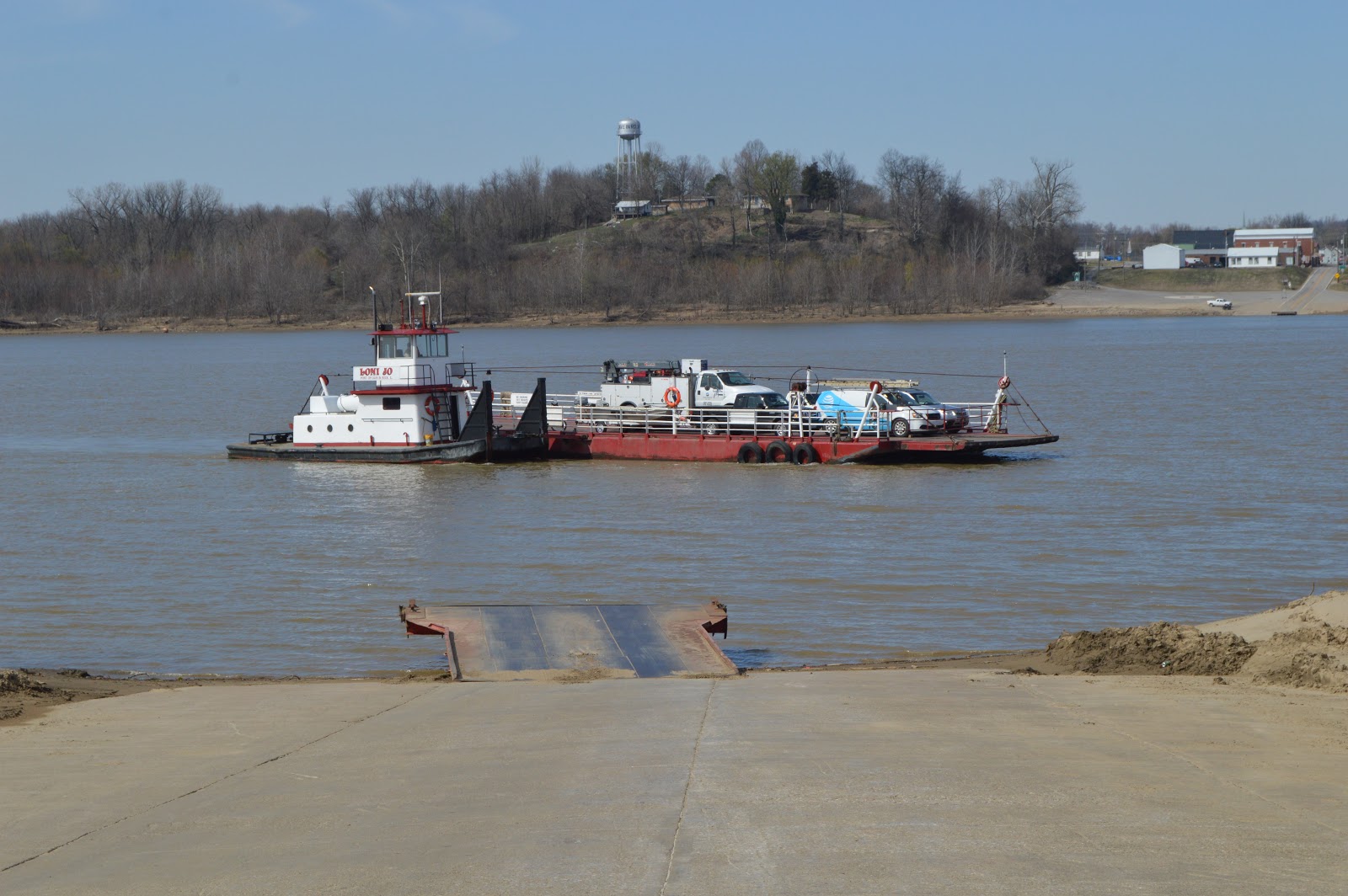
On one of my trips back to Chicagoland from Kentucky, I skipped my usual I-57 route and went out of my way so that I could ride this ferry. We arrived at the apron at 3:00.

20170322 8149

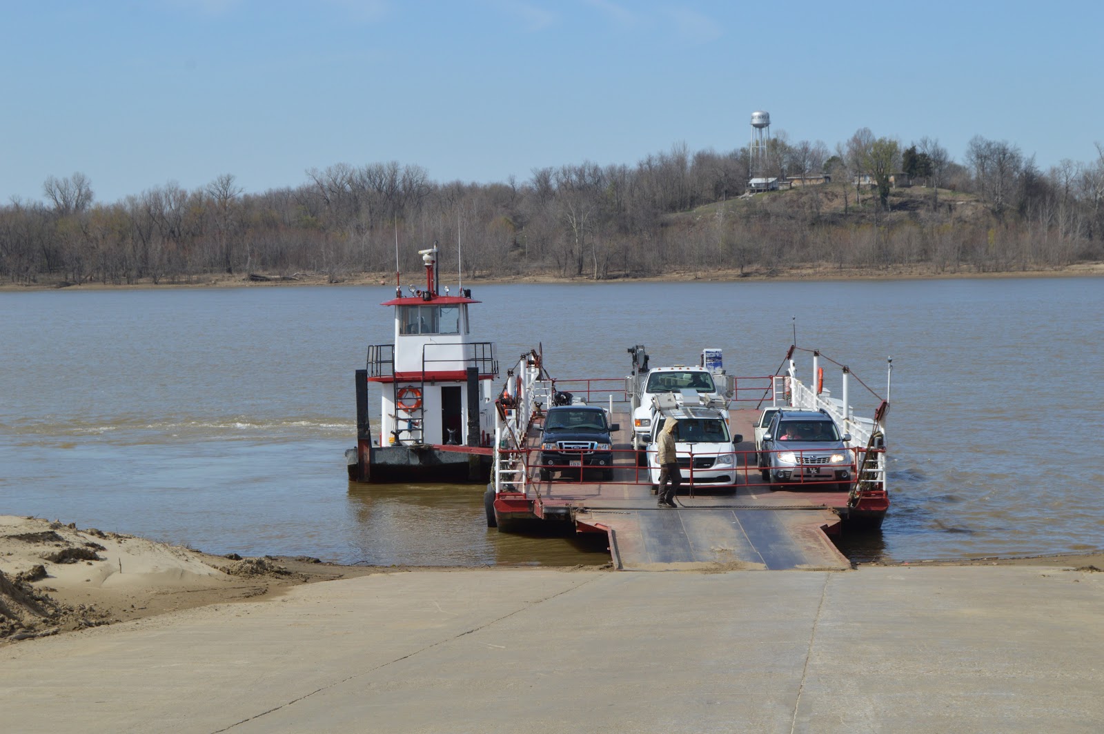
3:04:34  About four minutes later, the ferry had finished loading at the Illinois side and was pulling out. The towboat was in the process of turning around for the trip to this side. More about "turning around" below.
3:07:44  The above image was digitally cropped out of a photo that had this framing. I had not switched to my 55-200mm lens so I was shooting with my 18-55mm lens. Fortunately, that is good enough to get timestamps and the position of the ferry in the following photos as it crossed the Ohio River. It looks like it is going to head straight to the apron in this shot. But instead, it does quite a bit of maneuvering to deal with the current of the river. The river is flowing from right (east) to left (west).
 3:08:06
 3:08:34
 3:09:31
 3:09:49
 3:10:09
 3:10:43
 3:10:58
 3:11:11
3:11:20  As with drawbridges, cranes, etc., it is the fiddly bits at the end that take time.
3:11:24  After I noticed the propwash on the left of the pushboat, I noticed that there is a gap between the ferry and the east side of the apron. No wonder the guy at the gate has not opened the gates yet.
3:11:37  The big propwash indicates that a significant amount of power was needed to shove the ferry a little bit to the east.
 3:11:52  The helper is verifying the gap is closed.
 3:12:05  And opening the gates.
 3:12:27  So the traffic can leave.
3:12:46  Again, the truck goes in the middle.
After I parked the van, I got out to check things out. They don't bother to tie up the ferry for the short stay at the apron. They let the engine run to produce thrust to keep it shoved up against the apron. I believe this is called "keeping station." I've also seen this done when pushboats change crews.
That's my van at the head of the line. It must have been just us and the pickup truck on this crossing.
3:15:48  You can tell the boat was built as a pushboat because of the steps that would allow a crew to get on top of an empty barge. They have added a bracket to the center of the bow that is pinned to...
...a bracket added to the side of the ferry at its middle. As soon as it has pulled away from the apron, the rear of the boat is shoved away from the ferry and...
...pushed on around until...
 ...it is in position to push the ferry.

3:16:29
 3:16:38  We say goodbye to Kentucky.
As we saw in the satellite image, it throws a pretty big propwash when pushing the ferry.
3:20:10  We are getting closer to Illinois.
3:21:56  I got back in the van so I would be ready when they opened the gate since I'm the first one that needs to get off. The GPS understood we were in the river.
3:22:04  This was taken through the front windshield of the van. Four vehicles were lined up for the trip back.

Share:

Featured Post

Copper River & Northwestern Railway and its bridges

Mile 27, Flag Point Bridge: ( Satellite ; Blog ; more below) Mile 28: the bridge no longer exists; Blog Mile 34, Hot Cake Bridge: the bridge...