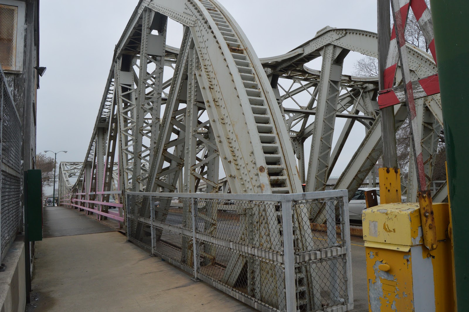
The paint job on this bridge is in remarkably good shape considering that it is supposed to be replaced in a year or so. The safety island allows a rather unique vantage point. The traffic heading west is backed up for blocks because two lanes squeeze down to the one lane of this bridge. But the traffic lights provide gaps in the eastbound traffic. When I go to Goose Island, I take Division Street east from I-94. But when I leave, I go south on Halstead.
It is a wide safety island, but it is still kinda creepy taking pictures there as traffic goes by.
Note the three big compression members branching out from the trunnion bearing just below the surface. The three exposed racks are typical of Chicago's first generation of trunnion bascule bridges.
I zoomed in on the above photo to show the westbound traffic is gridlocked for as far as you can see.
The Coast Guard removed the requirement that the bridges have to be movable. So if Chicago has not replaced a bridge with a fixed bridge, they have fastened the two bascule leaves together to make a stronger bridge. I would expect that they also removed the motors and wiring so that the copper was not stolen.
And now it is photo dump time as I walked west on the south side and then back east on the north side.
There are a lot of photos of the current Strauss trunnion-heel bridge. Photos of the swingbridge that existed before the tracks were elevated and the river was straightened are rare enough that they deserve there own posting rather than getting lost in the existing posting.
Paul Petraitis posted 11am 9/23/1905, Photo courtesy of the Metropolitan Water Reclamation District Ean Kahn-TrerasWe are looking off of 18th Street in this view. The elevated track is the IC iowa division curving for their crossing of the RI at 16th Street. Mark E. VaughanWasn’t the Erie carfloat interchange operation in this area also? Bob LalichThe Erie Lake Line had two stations, both of which were farther north. Information describing the operations can be found here: http://freepages.rootsweb.com/.../genealogy/erielakechi.html
Bob Lalich commented on Paul's posting The bridge seen here is the SCAL swing bridge. The yard here is C&WI's 18th St Yard. 16th St Tower can be seen in the distance. Here is the smoke abatement map of the area.
Paul's posting is also one of the better views I have seen of Burlington's grain elevators that were next to some slips off the South Branch.
James Boudreaux posted Elevating the St. Charles Airline from Chicago Union Stations' south main line. Bottom L/S quadrant is now Amtraks' 16th St. diesel shop and yard (ex Penn Central, Pennsylvania RR). Upper R/S quadrant is Metras' yard (ex CB&Qs' Zephyr Pit)
Below, in the background, is the Taylor Street rolling bridge in the upright position. It appears that a dredging machine is working under it. Or is it a marine crane that is removing the center pier for the former swing bridge?
Martin G. Sorenson posted Chicago circa 1900. "12th Street Bascule Bridge." Dinosaurs of the ... top (north) bridge is no longer in use - it served the old Grand Central Station (B&O and others) at Wells and Harrison until the late 50s. David DaruszkaThe boat is a tour boat of the recently completed "drainage canal". The Sanitary and Ship Canal was an engineering marvel, and the techniques used in it's construction were replicated at the Panama Canal. [This photo was taken from the 12th Street (Roosevelt Blvd.) Bridge, not of the 12th Street Bridge. This bridge was replaced by the Strauss bridge near 16th Street when the river was straightened.] Mike Savad posted a watercolor of this photo.
Taylor Street's swing bridge would not allow contemporary (1899, 478') ships to pass. The center pier also prevented the 300,000 cubic feet of water per minute flow required to flush the river down the new drainage canal. Removal of the center pier also provided the 120' navigation channel required by the United States War Department for the Chicago River. [eBook, p 696]
The swing bridge still exists in the background of this image of the B&OCT bridge.
Looking through the bridge in the foreground, we can see the Taylor Street swing span on the right and the viaduct to the west that crossed the Pennsylvania and CB&Q rail yards south of Union Station.
"Fig 4 is a general plan of the new Taylor street rolling lift bridge The span from centre to centre of bearings is 148 feet 7 inches. The roadway from centre to centre of trusses is 20 feet in width, with a 5 foot sidewalk on each side." [eBook, p 700]
Before the St. Lawrence Seaway was finished in 1959, boats traveled between the Great Lakes and the ocean (Gulf of Mexico) using the Illinois Waterway. I've already posted about the Marine Angel using the Chicago River in 1953. In comments concerning a Marine Angle posting, Frank Smitty Schmidt provided more examples of ships using the waterway.
Frank Smitty Schmidt commented on a posting The St Marys Challenger was at one time named the Elton Hoyt II. The vessel was renamed Alex D. Chisholm in 1952 following the launch into the Interlake fleet of a new hull christened Elton Hoyt II. Here's a picture of the new in 1952 Elton Hoyt II being towed through Joliet on it's way to Chicago. It was built in MD and towed up the Mississippi and Illinois Rivers and the Illinois Waterway on it's way to the Great Lakes. The pilot house was installed in South Chicago before it went into service. [Another name for this boat was the Madusa Challenger.]
Frank Smitty Schmidt commented on a posting The Illinois Waterway opened in the mid 1930's. The St Lawrence Seaway opened in 1959. From the mid 30's until the late 50's, the Chicago River, Illinois Waterway, and Mississippi River was the only connection between the Great Lakes and the oceans of the world. During WWII, ship building on both coasts were extremely strained, so there were a lot of submarines and smaller ships built on the great lakes and moved to the gulf. Here's a picture of a smaller ship that was raised on pontoons, tied to a barge, and moved to the gulf for final completion and launch. It just coming up on the Rock Island Railroad Bridge in Joliet. Yes, it would have came down the Chicago River in it's journey.
Jeff BranskyMore likely they used the Calumet River and the Sanitary and Ship Canal to bypass the Loop to get to the Illinois River then on to the Mississippi.
Frank Smitty Schmidt commented on a posting Surprisingly not very often. They were usually taken on the Chicago River. In fact the pictures of the Marine Angel posted were taken in 1953 while it was being moved to the great lakes.
Frank Smitty Schmidt commented on a posting This is a Gato class sub that was built in Sheboygan, and moved to the gulf on a floating drydock. Quite possibly you would have seen this on the Chicago River during the war. Dennis DeBruler That is setting in a lock with a small drop in water level. So that one is probably taking the Cal Sag. But I read that one of the few times the swing bridges on the Chicago Sanitary & Ship Canal were moved was during WWII to pass submarines built in Manitowoc, WI and Grebe mine-sweepers built on the North Branch.
Some comments on a posting concerning the mobility of the Illinois Northern swing bridge (and the other swing bridges on the CS&SC). Ramon RhodesAnthony Cac the bridge has only been opened a handful of times since it was built around 1902. There never was any machinery installed to open or close the bridge. The same is true for all of the railroad bridges east of the 21st lift bridge west to the bridge at Lemont. Fred Van DorpeRamon Rhodes Thats not true. Other bridges along the Ship and Sanitary Canal like the IC bridge near Kedzie ave. and the 8 track bridge at Ash St. junction are built to be moveable for a reason. There was definitely machinery originally on all the moveable type bridges for them to be opened. Its just been removed long ago. A bridge doesnt get built to be opened for boat traffic "only a handful of times." This article even states that the machinery for opening the various bridges was removed.
https://www.cityofchicago.org/.../Historic_Chicago... Ramon RhodesFred Van Dorpe I wrote a paper on the railroad bridges along the Sanitary Canal. My research indicated that none of the swing bridges were ever motorized. They had to be manually opened. That happened about 7-8 times during WW2 so that minesweepers built up river could reach the Gulf of Mexico without having to go through the St. Lawrence Seaway and the Atlantic.
Perhaps the person who wrote the article isn't aware of this. Note that there are no historic photographs anywhere of the swing spans from the CN bridge at Kedzie Avenue all the way down to Lemont open.
I will continue to do more research on this, but I believe that what I posted is the truth. Ramon RhodesFred Van Dorpe I recently found the paper that I wrote on the bridges and to be specific, none of the bridges were built with turning machinery in them. It was a cost-saving measure.
Briefly during World War II, machinery was installed in them, but it was later removed. 1953 was the last time they were opened and I suspect it was probably done manually. Dennis DeBrulerSo the Marine Angle going from ocean to Great Lakes service in 1953 was the last time the bridges moved. https://industrialscenery.blogspot.com/.../marine-angel... Update: Grebe Shipyard made three more minesweepers for the Korean War. The last one was shipped in 1954. So the Marine Angle was not the last ship to cause the bridges to swing. http://www.shipbuildinghistory.com/.../yachtsmall/grebe.htm
(Satellite, the site is now occupied by a townhouse development north of Belmont and between Washtenaw and the river. According to a 1938 aerial photo, some of the land north and to the west was also part of the shipyard.)
The bridges along the North Branch used to be movable up to, and including, Belmont Avenue. Grebe Shipyard took advantage of this navigation channel because they built some fairly large boats. It used to specialize in building custom luxury wooden yachts. They used exotic woods like teak and mahogany.
And the mahogany was not just for interior use. This boat was listed for $134,500. The listing indicated the hull material was "Double Planked Mahogany" and the deck material was Teak.
A Chicago Tribune article says the shipyard produced 200 luxury boats since it opened in 1926. But ShipBuildingHistory shows it producing boats since 1916. I reconciled these dates when I learned the company started in Milwaukee and then moved to Chicago. And it started with the name Great Lakes Boat Building.
I found someone's recollection that it closed in 1995. [YachtForums, Jeff Ondrla]
I first learned about this shipyard because they made minesweepers during WWII and the Navy installed machinery in the railroad swing bridges on the Chicago Sanitary and Ship Canal so that they could be opened to allow the minesweepers to get to the ocean via the Mississippi River. (The St. Lawrence Seaway would not open until 1959. The Navy also shipped other ships from Great Lakes shipyards down the Mississippi River such as Manitowoc Submarines.) I dug through a lot of luxury yacht photos before I figured out how to search for photos of mine sweepers. A collection of photos of their yachts is at the end of these notes.
The Navy wanted to build ships inland to avoid German U-boats. Sometimes they built a shipyard from scratch like the LST shipyard in Seneca, IL. In the case of Grebe, they just had to change the product line. I can't determine if the hull of the YMS class of minesweepers was steel or wood. I remember reading that Grebe was chosen to build wooden minesweepers because of their expertise and tooling to make wooden hulls. But a reference indicates that magnetic mines, and thus wooden hulled minesweepers, were not developed until the Korean War.
YMS Class Displacement is 270 British tonnes, length is 136', and the crew was 32 men. It had 2 shafts and 2000 hp. 494 ships of this class were built, which was, by far, the largest class.
YMS-84 was the first minesweeper built at Grebe. It was order 4-1-1941, the hull was laid down 6-2-1941, it was launched 3-3-1942, and it was commissioned 5-23-1942 [YMS-84]. I assume the period between launch and commissioning is when it made its trip between the North Branch of the Chicago River to the Gulf of Mexico. The last, and 25th, minesweeper built for the Navy by Grebe was YMS-421. It was ordered 7-21-1943 and commissioned 3-3-1945.
It struck me that minesweepers are one of the few military assets that continue to do their primary job after a war is won. A lot of mines had to be removed from the English Channel. During the war, they just cleared lanes across the channel.
During the Korean War, they built 3 more that were delivered in 1953-54. [ShipBuildingHistory] So the photo below would be of one of the three ships for the Korean War. During WWII, they also built 20 tugs, and in 1945 they delivered four water tankers that had a displacement of 440 tons and were 174' long. [ShipBuildingHistory]
Encyclopedia.ChicagoHistory U.S. Navy minesweeper under construction at Henry C. Grebe & Co. shipyard on the west bank of the North Branch of the Chicago River, June 1952.
Photographer: Louis F. Zimmerman Source: Chicago Historical Society (ICHi-37004)
[We can see they built them from the bow backwards. I don't see any cranes big enough to lift in pre-built modules like they developed for Liberty Ships.]
The above photo was driving me nuts. I already knew the power plant that we see on the left is west of the river. From the middle to the right background is obviously an amusement park. I have confirmed that it was Riverview. It was on the right side of the river. That means we are looking north. And the photo must have been taken with a really wide-angle lens. But I was curious how they were going to get the land-locked boat on the left into the river. In the following full resolution excerpt from a 1938 aerial, the big boats were built by the river. It looks like they built the smaller boats on transfer platforms. When done, I presume they moved the platform to the north/south "white strip" and then north to the boat ramp that lowered them into the water.
By 1952, the site looked completely different. The part to the west of the "white strip" may have been sold to others because that part changed between 1952 and 1962. The remaining site looked about the same in 1962, 1972 and 1988. It was cleared in 1999. But the part that changed between 1952 and 1962 looked the same in 1999.
A sampling of the Grebe yachts. Except for the Wanigan III at the end, I have sorted the photos into chronological order.
I don't know how permanent sales links are. So this Wanigan III link is an experiment: a 1949 76-foot yacht. The link accesses a lot of interior shots, including the engine room and crew bunks. I did copy a couple of photos in case the link breaks.
In case the link does break, I saved this image.
In case the link does break, I also saved this image.
(Satellite, north of Belmont between Western and the river)
I'm researching the location of the Riverview Amusement Park to help understand the orientation of this photo of Grebe Shipyard because the park is obviously in the right background.
For more typical photos of the park, see pintrest. GenealogyTrails has some details about the rides and more photos.
It occurred to me that amusement parks are a significant industry. The is more stuff in the world than just railroads and bridges. Take a look at Cedar Point, Holiday World (a family favorite), Disney Parks and Six Flags. We have already seen that interurbans built amusement parks to create business during weekends such as Dellwood. I remember going to Elitch Gardens in Denver when it was in its original location and had gardens and a ballroom. I've also gone to their newer location that reused abandoned railroad yards.
Riverview started either as a skeet-shooting club that added some rides to entertain the wives and children of the shooters [ChicagoTribune-remember] or as a sharpshooter park whose son added rides after he saw some of them during a trip to Europe. [DefunctParks, Richiezie].
Riverview eventually could claim the title of the "world's largest amusement park," its area and number of rides far outnumbering those at the more famous and sprawling four-park setup at Coney Island, N.Y., and of such rival local playgrounds as White City or Joyland on the South Side. Its slogan was simple — "Laugh Your Troubles Away" — and through world wars and a Great Depression, through divorces and deaths that's what people did. For the first generations of visitors, Riverview was the only place to take a boat ride, either on the wild slide that was Shoot the Chutes or on the more leisurely Tunnel of Love. For its early visitors it represented a place where the machinery of industry was transformed into things of play as it took the city from the Victorian age into the modern world. [ChicagoTribune-remember]
It featured what some insist was the finest roller coaster of all time, The Bobs. Other popular coasters were The Comet, The Silver Flash, The Fireball and The Jetstream. Aladdin's Castle was a classic fun house with a collapsing stairway, mazes and turning barrel. [ChicagoTribune with 49 photos] "In 1926 'The Bobs' was added an 11 - Car Roller Coaster with an 85 foot drop. The most fearsome Roller Coaster in America at the time, it was the fastest on record. The Bobs carried 1,200 passengers per hour it drew over 700,000 rides each season. The Bobs was the most popular ride throughout Riverviews Park existence." The 74-acre park entertained over 200,000,000 people before it was sold Oct 3, 1967 for $6.5m ($85+ in today's money). [Richiezie] The merry-go-round, with its hand-painted horses, was purchased in 1971, and it is now in "Atlanta at Six Flags Over Georgia." [whgbetc] When the park closed on Sept. 1, 1967, it had 120 rides, including six rollercoasters, a parachute jump and rockets. [GenealogyTrails]
Despite being seen as a success to many, the park was sold on October 3rd, 1967. Shortly after, an article from the Chicago Tribune blamed violence for the park’s closure as Schmidt admitted that crime was a motivation for selling. Minorities felt increasingly uncomfortable as racism became more common. Aside from being made to feel generally unwelcome African Americans found themselves in complete outrage with the addition of an attraction called “Dunk The N*****” which was renamed “The African Dip”. Among this, increasing taxes, maintenance and more led to the fall of one of the greatest amusement parks of its time. Stories of Riverview have been passed down through generations and will most likely continue to be. [DefunctParks]
EncyclopediaChicagoHistory Reverview Postcard, 1909 [Chicago was the birthplace of amusement parks that featured mechanical attractions. Please click the caption link for an interesting history.]
I read a couple of years ago that the Western overpass of Belmot was going to be removed. It was originally built to handle the traffic generated by the Riverview Amusement Park. Since the park is gone and the overpass needed repairs, it was decided to get rid of it. A street view shows this work is done. Given that it is a five-way intersection, I'm glad I don't have to use it.
Street View On Belmont east of Western Avenue looking West at Western Avenue
But a satellite image still shows what it used to look like.
Vince Black posted Darla ReichwaldAt the end of Aladdin's Castle there air would shoot up to blow the girls skirts up over their heads. We never wore skirts to Riverview. Sara FiebergRiverview, Aladdin's castle, room of doors where you were channeled into a maze and had to find the right door in each group to go forward. Barrel roll. And the parachute jump! That was a test of courage! All the sailors with their girls sneaking a kiss at the ball toss booths.Shirley HartfordAladdin’s Castle was so much fun. The mirrors, the big roller to walk thru the crooked floo
Jerry Kasper commented on Vince's posting Remember the magic.