I learned about this dam because it was part of a tour of dams taken by two of the engineers for the Chicago Drainage Canal (now the Chicago Sanitary & Ship Canal). They studied the 80' bear trap gate at this dam to refine their design of a 160' bear trap gate for the CS&SC control structure. [Building the Canal to Save Chicago by Richard Lanyon, p55]
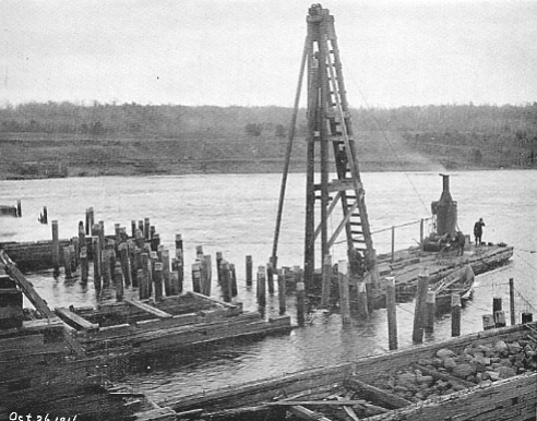
The St. Croix River was like the Muskegon River in that a lumber industry used it to float logs from the forest down to saw mills. Another similarity is that the dams on the rivers use a bear trap gate to pass the logs over the top. When the Nevers Dam was built in 1889, it was the largest wooden dam in the world, and the 80' bear trap gate was the longest gate in the world.
The wooden piers were built on top of piles and filled with stone. The road built across the dam was the only road across the river in the region. The truss bridge spans the 80'x20' bear trap gate and the 13 other gates were 16'x24' Tainter gates. The builder, Robert A. Lang, was the inventor of the bear trap gate.
 |
| dnr.state.mn.us |
 |
| J.R. Frawley Photo |
 |
| J.R. Frawley Photos |
By 1903 the logs were pretty well gone so the Northern States Power Co. bought it as a river control point for the hydroelectric power dam it planned to build 11 miles below at St. Croix Falls. The last log was sluiced through in 1912.
After 1955, the power company hired a two-man well-driller crew to take 100s of samples of the river bottom. But the results were that the sand and gravel extended down as far as 113' with sandstone beneath that. Northern States Power was evidently not aware of the Tumble Bays, long aprons, and pier keys used by the Midwest power companies to build concrete dams without a viable bedrock. For example, the Elkhart Hydro Dam.
[dnr.state.mn.us]


No comments:
Post a Comment